Overview - updated January 2026
This page has a full description of this section of the trail, including supporting photographs. You can read this page and/or
Starting point
The starting point is the end/start of the Seascapes Interpretive Walkway at Seascapes Beach, opposite the end of Sugarwood Terrace. There is carparking on Boardwalk Boulevard.
Getting there using public transport
The best way to get using public transport is to is to catch bus 592 which starts at the Mandurah train station. Get off at the bus stop on Peelwood Parade just passed Breynia Link. Head back up Peelwood Parade about 20m and turn left into Sugarwood Terrace, which will take you to the starting point – about 300m.
Turn around point
The turn around point is Falcon Bay Beach.
Getting back to the start from the turn around point – if you don’t want to do an out-and-back walk
The best way to get back to the start using public transport is to catch bus 592. From Falcon Bay Beach, walk down Thera Street (directly opposite the beach) about 250m and turn left into Corfu Street. The bus stop is about 50m along. Bus 592 will eventually go down Peelwood Parade, and exit the bus at the stop just passed Stellaria Ave. Walk about 20m and turn into Sugarwood Terrace, which will take you to the starting point – about 300m. The bus also goes to Mandurah train station.
Summary of the walk
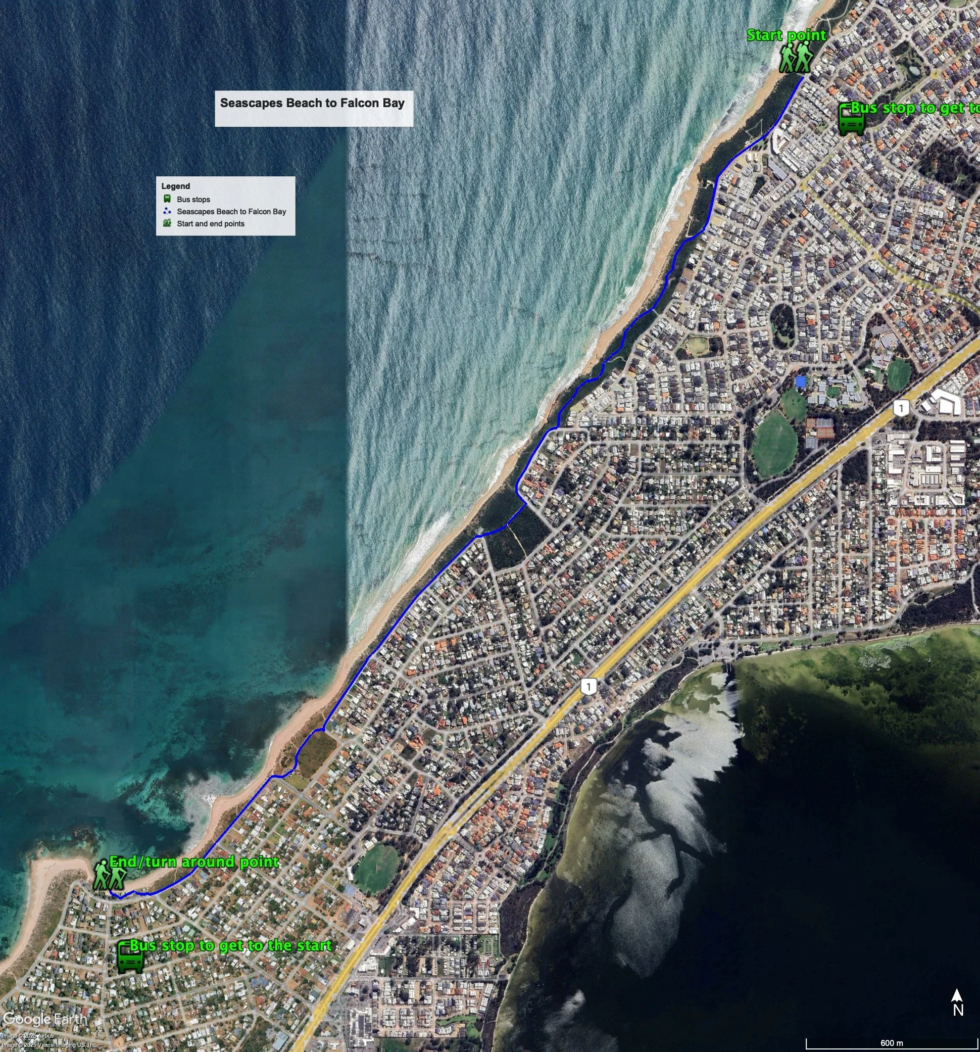
Figure 1 below shows the route. The total one-way distance is 4.00 km, making it an 8.0 km out and back walk.
Water and toilets
Any toilet blocks are noted below in the text in italics. These are also sources of potable water. Any additional drinking water taps and showers are also noted in italics.
Figure 1
Walking guide
From the starting point, head down Boardwalk Boulevard on the path (on the ocean side of the road) through a park, with a shower and drinking tap a playground and two lookouts, which is adjacent to a developing small coastal node with apartments being built and a shopping area with at least one café. (Plate 2).
Plate 1: The path down Boardwalk Boulevard
Plate 2: Small coastal node with park, new apartments and small shopping area with cafe
Continue on along the path, which is now Acerosa Boulevard, and after about 200m you will see a toilet block on your right. Where Acerosa Boulevard ends and the road turns sharply left (another 150m) you will see the start of the coastal path that runs through the foreshore reserve. Take this path (Plate 3).
Plate 3: Start of the coastal path that runs through the foreshore reserve
After about 800m of very scenic walking, including a couple of boardwalks and views of the limestone beaches (Plate 4), the path ends at Gretel Drive.
Plate 4: Views along the coastal path
Follow the path along Gretel Drive for about 250m where the road bends left. Follow the path along the road for about 50m and you will see the next coastal path through the foreshore on your right. Take this path (Plate 5).
Plate 5: Next coastal path – the start can be seen just around the bend in the road and next to the lamp post
After about 100m you will see a path off to the left with a ‘lookout’ sign. The lookout is about 70 along and well worth a visit (Plate 6, also just visible in Plate 5), with views to both the ocean and the estuary (Plates 7 and 8).
Plate 6: The look out
Plates 7 and 8 – views from the lookout to the ocean (7) and estuary (8)
Plates 7 and 8 – views from the lookout to the ocean (7) and estuary (8)
Return to the coastal path which ends in another 100m, coming out at Spinaway Parade. Follow the path along Spinaway Parade for about 850m where the road bends sharply left to go around Cooranga Reserve. Take the path through the reserve (Plate 9), and after 100m you will see another lookout on your right (Plate 10).
Plate 9: Path through Cooranga Reserve
Plate 10: lookout
The path goes through a small park with picnic facilities, and then onto Spinaway Parade. Falcon Bay beach is about 750m along Spinaway Parade where there is a toilet block and facilities, as well as a café (Plate 11). This is the turn around point.
Plate 11: Falcon Bay Beach – the turn around point
Garry Middle, January 2026


