Overview - updated January 2026
This page has a full description of this section of the trail, including supporting photographs. You can read this page and/or
Starting point
The starting point is the carpark near the southern end of Warnbro Beach Road (the road actually continues but heads inland and becomes Shelton Street).
Getting there using public transport
The best way to get there using public transport is by bus 557 from Rockingham Station, which travels down Safety Bay Road, getting off at the stop between Hilda Road and Fendam Street. It’s a walk of around 700m to the carpark, via Hilda Road and Shelton Street.
Turn around point
The turn around point is about 200m passed the carpark at the western end of Bayeux Ave.
Getting back to the start from the turn around point – if you don’t want to do an out-and-back walk
The best way to get back to the start using public transport is catching the 560 bus. Walk up Bayeux Ave (400m) and turn right onto Grand Ocean Boulevard about 100m to the bus stop. Get off the bus at the stop just after the bus turn onto Hokin Street, before Safety Bay Road. It’s a walk of about 1.2km via Hokin Street (head south), Reveley Street, Jones Place (on the left), on to Blakey Street and left at Shelton Street.
Summary of the walk
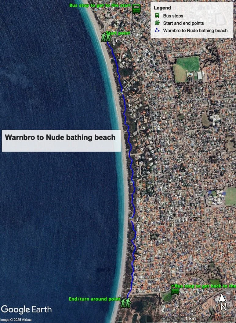
Figure 1 below shows the route. The one-way distance is 3.3 km, making it a 6.6 km out and back walk.
Water and toilets
Any toilet blocks are noted below in the text in italics. These are also sources of potable water. Any additional drinking water taps and showers are also noted in italics.
NOTE: there are no toilets on this walk, but there are three showers, which can be used for drinking water – one at the start, one after about 500m and one at the turn around point.
Figure 1
Walking guide
This is an easy walk where you just follow the concrete/bitumen path through the dunes. The Foreshore here is very wide and well vegetated and the houses are well set back from the ocean. In general, the path runs through the middle of the reserve. It is very undulating and there are several viewing areas on the highest dunes, which can be accessed from the path.
It should be noted that there are no toilets on this walk, but there are three showers, which can be used for drinking water – one at the start, one after about 500m and one at the turn around point.
From the carpark (Plate 1) near the end of Warnbro Beach Road, head south a short distance along the concrete path until you arrived at where the road bends to the left, the foreshore reserve widens significantly and the path cuts through the dunes (Plate 2).
Plate 1: Carpark near the southern end of Warnbro Beach Road.
Plate 2: Southern end of Warnbro Beach Road with the coastal paths through the dunes visible.
As noted above, this is a straightforward but highly enjoyable walk, as the path meanders through the dunes (Plate 3).
Plate 3: View of the path, dunes, foreshore reserve and the ocean.
There are a couple of lookouts constructed on the higher dunes, which can be accessed from the main paths. The views from these are worth the climb (Plate 4).
Plate 4: View from one of the lookouts.
The residential area adjacent to this path is known as Warnbro Dunes. The development was allowed to proceed provided that the dunes themselves were not flattened or landscaped. To accommodate this, the blocks are very large, most with houses on the top part of the dunes (see plate 3 above).
After about 3.5 kms, you will arrive at a carpark and the end of the residential area. Beyond here, the large Port Kennedy reserve abuts the foreshore reserve (Plate 5).
Plate 5: Carpark at the end of the residential area and the start of the Port Kennedy reserve.
Continue along the path for several hundred metres until you come to a sign for the nude bathing beach (Plate 6).
Plate 6: The nude bathing beach near the start of the Port Kennedy reserve.
This is the turn around point.
For a bit of variety, it’s worth doing some beach walking on the way back, and there are plenty of tracks to take away from the beach that will talk you back to the path.
Garry Middle, January 2026


