Overview - updated January 2026
This page has a full description of this section of the trail, including supporting photographs. You can read this page and/or
Starting point
The starting point is the car park at the end of Madora Beach Road.
Getting there using public transport
The best way to get using public transport is to catch bus 584 from the Lakelands train station and get off at the first bus stop on Challenger Road and head north for 100m and then turn left into Madora Beach Road for about 250m to the Madora Beach Road from the car park.
Turn around point
The turn around point is the small carpark at the end of Orion Roan on Ormsby Terrcae, Silver Sands.
Getting back to the start from the turn around point – if you don’t want to do an out-and-back walk
The best way to get back to the start using public transport is taking bus 584. Head south-east along Orion Road for about 400m and turn right (south) on Mandurah Terrace - you can walk through the park on the western side of Mandurah Terrace. The bus stop is about 200m down Mandurah Terrace. The bus heading north will take you back to the start bus stop.
Summary of the walk
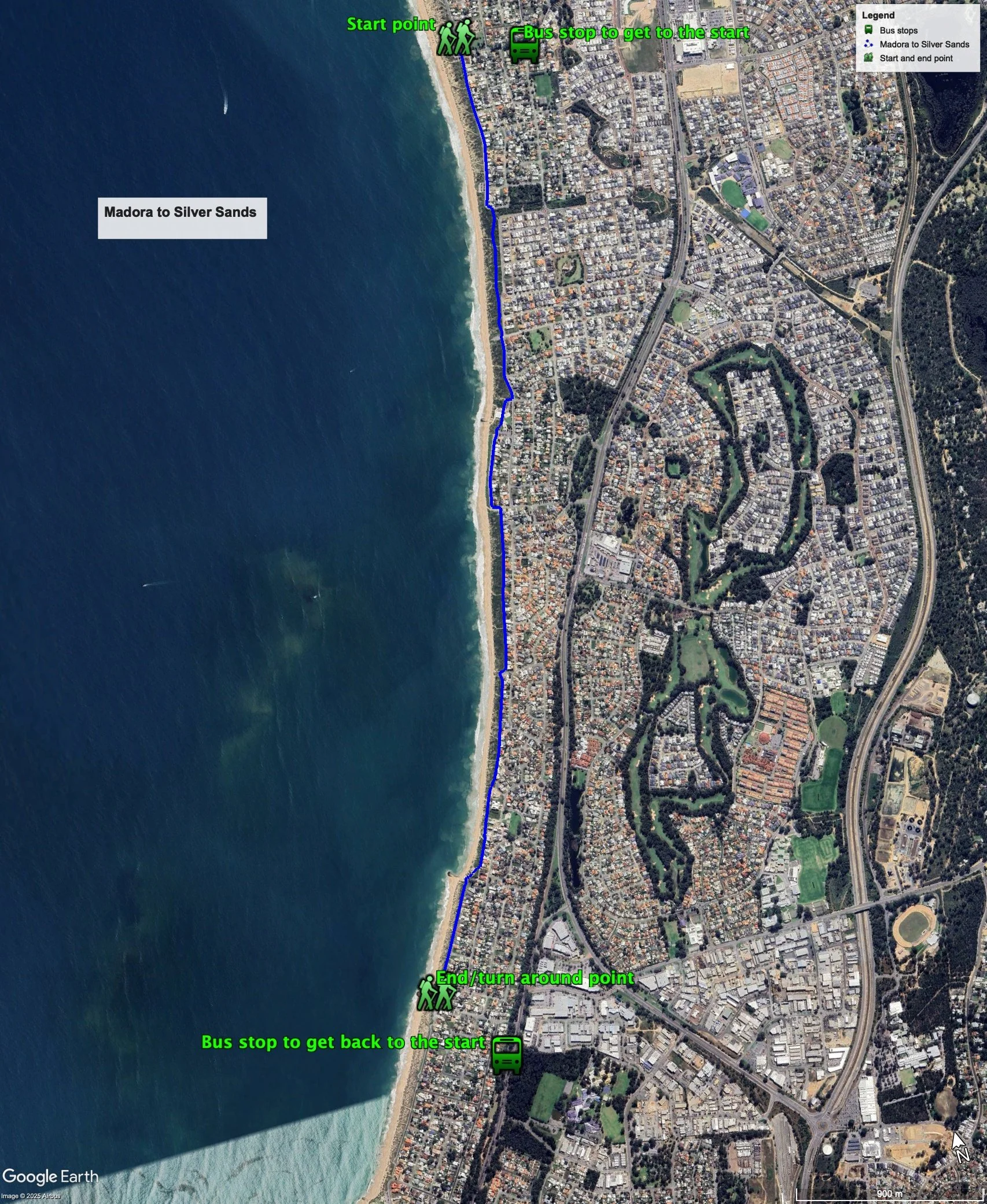
Figure 1 below shows the route. The total one-way distance is 5.0 km, making it a 10.0 km out and back walk. This is a long but easy walk.
Water and toilets
Any toilet blocks are noted below in the text in italics. These are also sources of potable water. Any additional drinking water taps and showers are also noted in italics.
Figure 1
Walking guide
At the carpark there is a shaded viewing platform (Plate 1).
Plate 1: Viewing platform at starting carpark
From the carpark, which has a toilet block, head south along Sabina Drive, through another carpark with a toilet block, for about 800m where Sabina Drive ends. Turn left and then after a short distance turn right onto a path (Plate 2).
Plate 2: Path at the end of Sabina Drive
Follow the path for about 1km and you will arrive at the Mandurah Surf Life Saving Club at San Remo (Plate 3). There are toilets, showers and drinking fountains here.
Plate 3: Mandurah Surf Life Saving Club at San Remo
Follow the path at the western edge of the park adjacent to the surf club, and onto Ormsby Terrace (Plate 4).
Plate 4: Path onto Ormsby Terrace from surf club reserv
The path here is on the eastern side of the road.
Continue down Ormsby Terrace for about 400m, where the road ends turns left and become Archeron Road. After a short distance turn right onto a path (Plate 5) which runs in front of a row of houses, forming the western boundary of these properties (Plate 6).
Plate 5: Start of path that runs in front of a row of houses
Plate 6: The path that runs in front of a row of houses
After about 800m the path come out into a small carpark, with a lookout at the southern end (Plate 7), with nice views north and south (Plate 8).
Plate 7: The lookout
Plate 8: View from the lookout
The path continues south passed the lookout again running in the front of a row of houses (Plate 9).
Plate 9: Second part of the path that runs in front of a row of houses
After about 1km, the path veers right through a small carpark (Plate 10), with a shower and drinking tap.
Plate 10: Path into the small carpark near the end of the walk
There is a small rock groyne here constructed to stabilise the erosion at this beach (Plate 11).
Plate 11: Small rock groyne constructed to stabilise the erosion at this beach
Head south along the path which runs on the western side of the road for about 600m where there is a carpark and toilet block (Plate 13).
Plate 12: Carpark at the end of the walk
This is the turn around point
Garry Middle, January 2026


