Overview - updated January 2026
NOTE: this walk is now a bit messy at the start because of the construction works for the upgrade to Ocean Reef Marina.
This page has a full description of this section of the trail, including supporting photographs. You can read this page and/or
Starting point
The starting point at the time of writing (January 2026) is existing boat launching area at the south end of the marina.
Getting there using public transport and starting point
The best way to get using public transport is to catch the Joondalup line train to Joondalup train station, and take the 460 bus. The Nearest bus stop is on Hodges Drive it’s the only bus stop on Hodges Drive, just after the bus turns right off Constellation Drive, and it’s a 1.1km walk to the starting point. Walk west along Hodges Drive to the roundabout at the end – about 500m.Turn left onto Ocean Reef Road and after 200m turn right onto the road that takes you to the marina and continue to the main park – 330m.
NOTE: at the time of writing the 460 does not have a weekend service.
Turn around point
The turn around point is South Mullaloo beach carpark on Northshore Drive, about 1.2km past Mullaloo Surf Life Saving Club.
Getting back to the start from the turn around point – if you don’t want to do an out-and-back walk
The best way to get back to the start using public transport is walk up to Northshore Drive and turn left, and it’s a very short walk to a bus stop for the 460 bus. Get off the bus at the above bus stop on Hodges Drive, and take the same walk back to starting point - the park near the waterbody in the Ocean Reef marina.
Summary of the walk
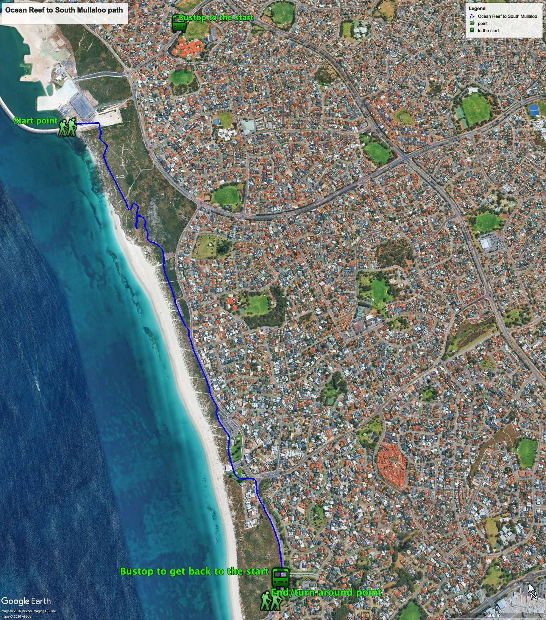
Figure 1 below shows the route. The total distance one-way distance is 4.2 km, making it an 8.4 km out and back walk.
Water and toilets
Any toilet blocks are noted below in the text in italics. These are also sources of potable water. Any additional drinking water taps and showers are also noted initalics.
Figure 1
Walking guide
This walk is described walking south from the starting point.
At the starting point there is a toilet block, drinking tap and shower (as at January 2025). Take the path that heads south from the park.
The paths changes to red bitumen path and takes a sharp turn to the left, and after about 140m takes sharp turn to the right to then heads mostly parallel to the coast. After about another 350m, there is a small lookout (Plate 1).
Plate 1: Small lookout
After another around 300m, there is track off to the left which leads to Ocean Reef Road, so continue straight on. After another 150m there is another path off to the left (Plate 2).
Plate 2: Track junction with the path straight on goes to a lookout and the path off to the left is a continuation of the coastal path
The path that continues straight on leads to a lookout (Plate 3), and the path off to the left is the coastal path, which you take after visiting the lookout.
Plate 3: The lookout
About 1.1km after returning to the main path, after walking past two carparks, the path joins, and runs parallel to, Oceanside Promenade (Plate 4).
Plate 4: Where the path joins, and runs parallel to, Oceanside Promenade
After another 550m the path bends right around a large carpark for the Mullaloo Beach parklands (Plate 5).
Plate 5: Where the path bends around the Mullaloo Beach carparks
Take the bitumen path that veers right and goes between the parkland and the foreshore, past a toilet block, past the surf lifesaving club which has a café, toilet block and showers, and though another park. The path heads away from the coast and heads towards the major roundabout at the intersection of Mullaloo Drive and Oceanside Promenade, which becomes Northshore Drive (Plate 6).
Plate 6: Where the path heads towards to major roundabout before bending right to run parallel to Northshore Drive
The path continues on the coast side of Northshore Drive, crosses over Merrifield Place and then runs parallel to Northshore Drive but set back about 15m.
Continue along this path for about 750 where you will arrive at a carpark, which is the turnaround/end point (Plate 7). There is usually a coffee van here in the mornings and early afternoons. There are no facilities here.
Plate 7: Carpark at the turn around/end point.
© Garry Middle, January 2026


