
Overview - Updated January 2026
This page has a full description of this section of the trail, including supporting photographs. You can read this page and/or
Starting point
TThe starting point is the main beach within Hillarys Boat Harbour.
Getting there using public transport and starting point
The best way to get using public transport is to catch the 423 bus from either Stirling or Warwick train stations. There is a bus stop opposite the beach just before the roundabout at Seychelles Link.
Turn around point
The turn around point is the North Beach Jetty.
Getting back to the start from the turn around point – if you don’t want to do an out-and-back walk
The best way to get back to the start using public transport is to catch the 423 bus. From the jetty head south along the path, and re-joins the main path. Continue for about 60m to the bus stop for the bus heading north. This will take you back to the start. This bus can also take you to into Warwick or Stirling train stations (take the bus heading south for Stirling Station.
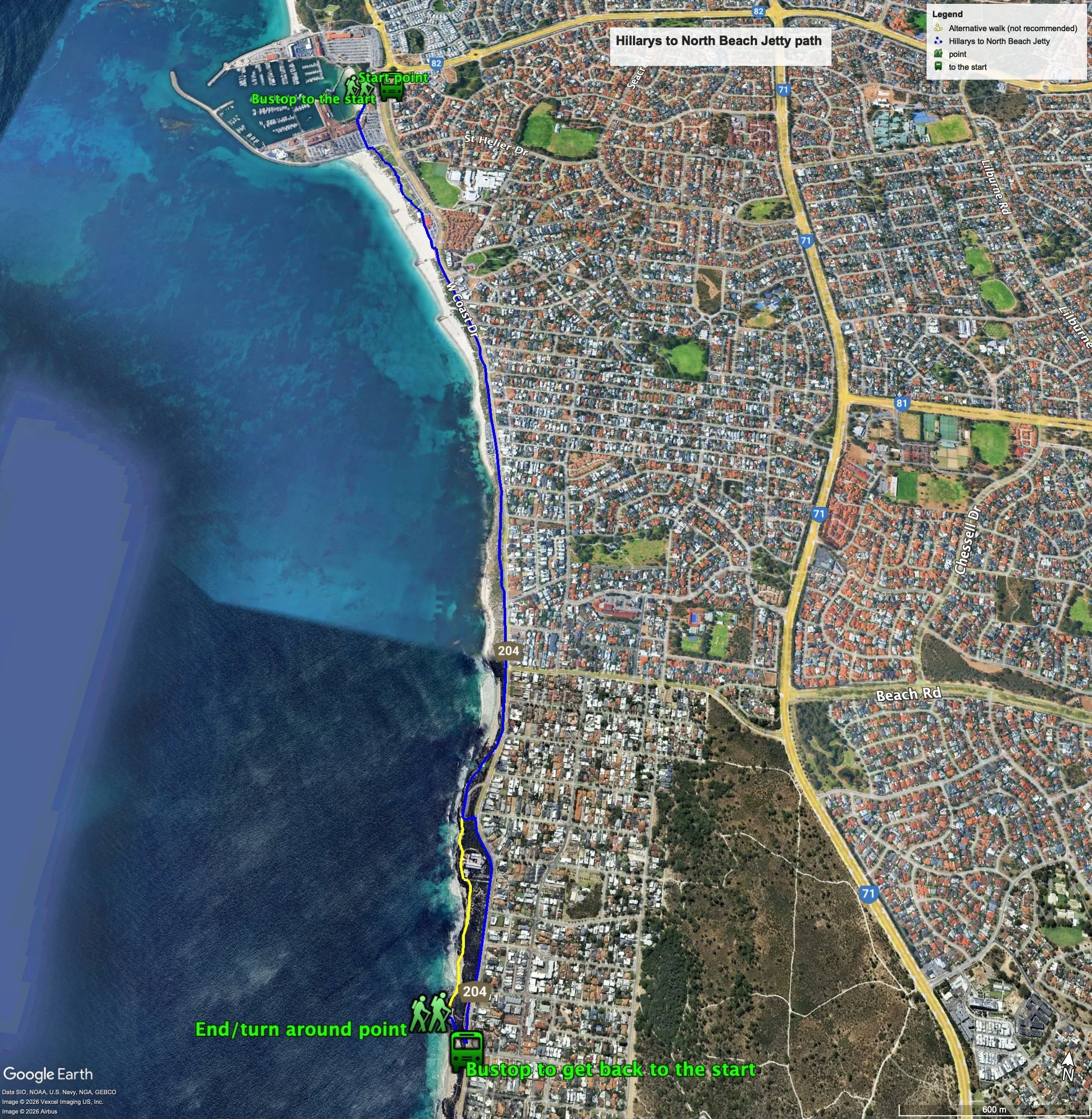
Summary of the walk
Figure 1 below shows the route. The total one-way distance is 4.3 km, making it an 8.6 km out and back walk. The two short alternatives add very little to the distance of the walk.
Water and toilets
Any toilet blocks are noted below in the text in italics. These are also sources of potable water. Any additional drinking water taps and showers are also noted in italics.
Figure 1
Walking guide
This walk is described walking south from the starting point.
There is a toilet block at the beach area as well as a couple of stand-alone showers and taps.From the beach head south through the commercial area and carpark of Hillarys Boat Harbour, and, at the end of the carpark, cross the boundary road at the crosswalk, and head east on the footpath until you reach a some steps just opposite a speed hump (Plate 1).
Plate 1: The steps up to Sorrento Beach from Hillarys Boat Harbour carpark

Take the steps, which lead to the main grassed area of Sorrento Beach. Head along the path at the western edge of the grassed area. In 2016 a shark enclosure was installed here but was removed in 2020 as it was damaged and likely to not be effective. It has not been replaced since. Plate 2 was taken in 2018 and is the sign explaining the enclosure and where it was located.
Plate 2: Swimming enclosure at Sorrento Beach - taken in 2018

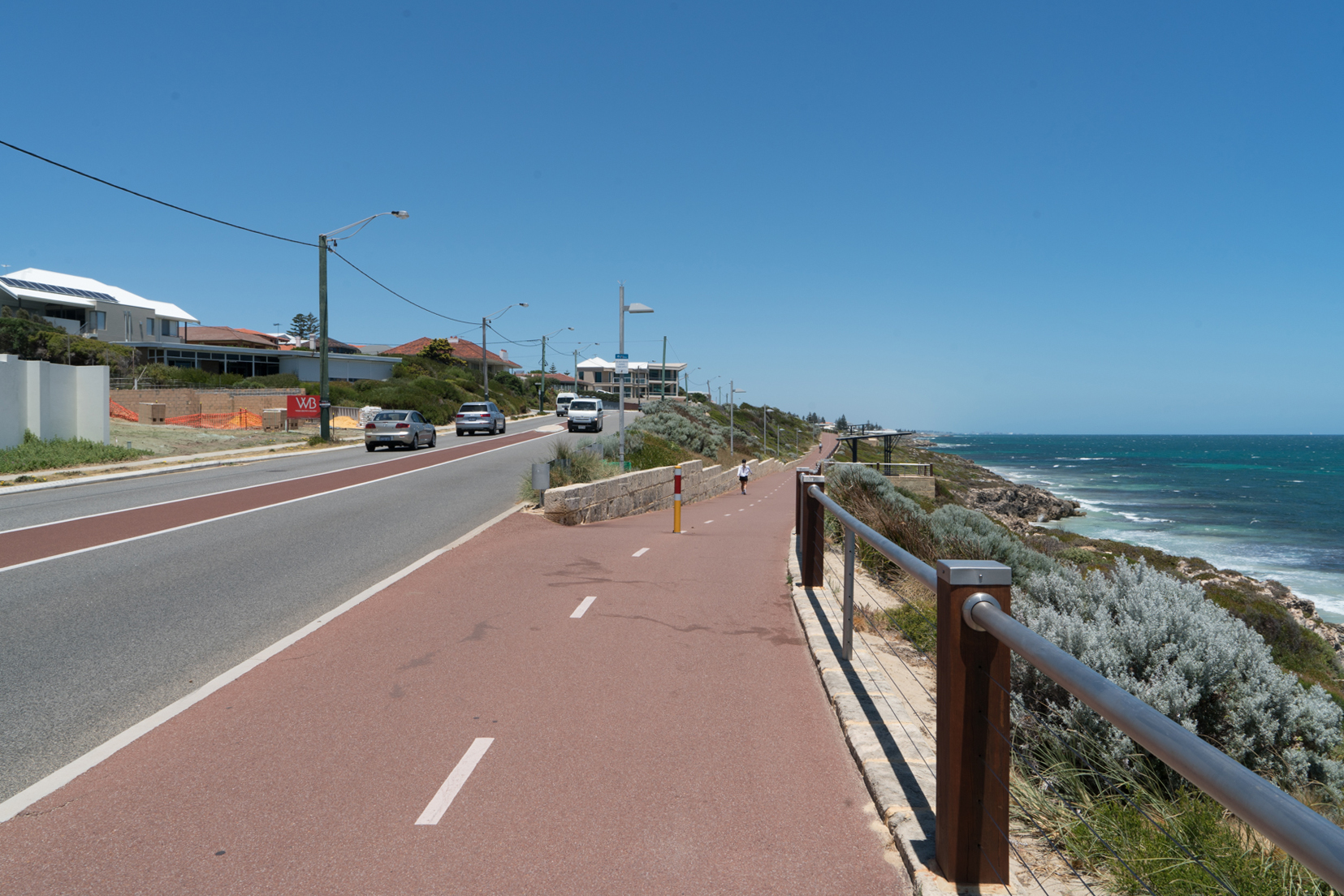
There is a toilet block at the beach area as well as several stand-alone showers and taps. Continue on the path on the beach side of the Sorrento surf lifesaving club, passed the carpark. The carpark narrows at its southern end and the main dual use path that runs parallel to West Coast Highway becomes visible – take this path and head south (Plate 3).
Plate 3: Dual use path that runs parallel to West Coast Highway at the southern end of the carpark.

Continue on the path for about 800m passed a small carpark and then a larger on at the Marmion Angling and Aquatic Club. There is a toilet block at the southern end of the carpark and a of stand-alone shower and tap at the northern end. After another 120m the path head away from West Coast Highway closer to the coast, and offers great views (Plate 4).
Plate 4: The path heading away from West Coast Highway.
After another 600m there is another path that goes off to the right leading to a playground and picnic area (Plate 5) Take this path.
Plate 5: Path through playground and picnic area.

Take this path which passes another small grassed area and then onto the carpark at Watermans Bay observation area. There are options to proceed from the southern end of the carpark.
The recommended option it to head back up to the main dual use path up a steep path (Plate 6), and follow the dual use path to the end, another 750m. If you take this recommended option - i.e. the main dual use path from Watermans Bay - after about 650m there is a small carpark and then just after this you will notice a path on the right going off at a sharp angle just before Malcolm Street that will take you to the North Beach jetty – the turnaround point. There is a of stand-alone shower and tap just near the jetty.
Plate 6: Steep path upfrom at Watermans Bay observation area carpark.

The first alternative is to take the boardwalk (Plate 7) and then rough path through the foreshore (Plate 8) and passed the Indian Ocean Marine Research Centre. This alternative is NOT recommended as the rough path is on fragile ground and already showing signs of erosion due to over use.
Plate 7: Boardwalk from Watermans Bay observation area carpark.

Plate 8: The rough path after the boardwalk.

Just passed the Research Centre, you can either head back up to the main dual use path, or continue along the rough path (Plate 9).
Plate 9: Start of path passed the Research Centre (right) and path up to main dual use path (left).

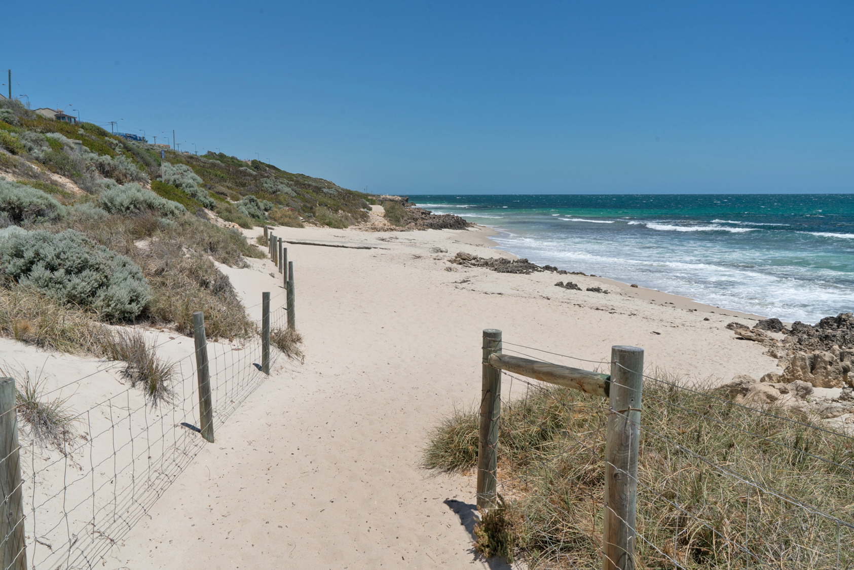
It’s about a 600m walk through two small beaches and two limestone cliff areas. This path is less vulnerable to erosion, but can be hard going in the sandy sections and on the two beaches (Plate 10).
Plate 10: One of the two small beach on the second alternative route.
This section is also accessible if you take the recommended route from the Watermans Bay carpark. Just passed the Research Centre, take the sandy path that heads to the coast, and after about 80 turn left into the path (Plate 9 above).
About 50m from the second beach you will come to the North Beach jetty and lookout – this is the turnaround point (Plate 11).
Plate 11: North Beach jetty.

There is a of stand-alone shower and tap just near the jetty.
Garry Middle, January 2026