
Overview - updated in January 2026
This page has a full description of this section of the trail, including supporting photographs. You can read this page and/or
Starting point
The starting point is the carpark at the end of Boundary Road.
Getting there using public transport
The best way to get there using public transport is by bus 551 from Rockingham Station, getting off at the stop just south of the intersection of Safety Bay Road (the road the bus takes) and Boundary road. It’s a 600m walk to the foreshore carpark.
Turn around point
The turn around point is the tip of Tern Island.Tern Island continues to generally grow or accrete and may erode in winter after a severe storm. The end point may well be a ‘movable feast’!
Getting back to the start from the turn around point – if you don’t want to do an out-and-back walk
The best way to get back to the start using public transport is taking the 551 bus. This bus terminates about 150m from the carpark next to the yacht club. Walk to the roundabout and head north along Safety Bay Road. Take the first left into Penguin Road, and the bus stop is just ahead before Carlisle Street. Get off at the bus stop just south of the intersection of Safety Bay Road and Boundary road
If you want to get back to the Rockingham train Station, the three buses that terminate at this bus stop will take you there – 551, 552 and 553.
Summary of the walk
Figure 1 below shows the route. The one-way distance is 4.1 km to the end of Tern Island and an extra 900m walk back to the foreshore, making it an 8.2 km out and back walk.
Water and toilets
Any toilet blocks are noted below in the text in italics. These are also sources of potable water. Any additional drinking water taps and showers are also noted in italics.
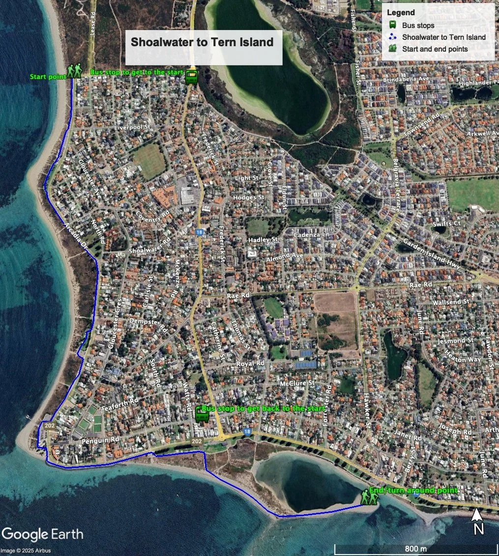
Figure 1
Shoalwater Islands Marine Park & Reserve
The islands and the marine environment between the Islands and the beach make up the most ecological significant area of the Shoalwater Islands Marine Park & Reserve. Figure 2 shows the boundary of the Park and is taken from the approved Management Plan. This can be downloaded from this link - https://www.dbca.wa.gov.au/management/plans/shoalwater-islands-marine-park

Figure 2: Map showing the boundary and zones of the of the Shoalwater Islands Marine Park & Reserve
The Park is not only significant for its environmental values, but also for its recreational values – swimming, boating, fishing, wind and kite surfing, and diving.
Walking guide
From the carpark, head south along the concrete path which, for the most part, marks the edge of the foreshore reserve (Plate 1).

Plate 1: The start of the walk
This path continues all the way to Mersey Point and then on to Tern Island, and offers, for the most part, sweeping views over the Islands, the main one being Penguin Island. (Plate 2)

Plate 2: Views to the Islands that make up part of the Shoalwater Islands Marine Park & Reserve
There is a toilet block at the first carpark you come to about 300m from the start.
Before arriving at Mersey Point you can take a detour through Lion Park and walk along the beach to Mersey Point (Plate 3).

Plate 3: Paths through Lion Park and to the beach
There is a jetty at Mersey point where the tour ferries depart from (Plate 4). These ferries go to Penguin Island and the other islands, notably Seal Island. Note - Penguin Island is the only island where people are allowed to visit.

Plate 4: Ferry jetty at Mersey Point - the ferries visible in the background.
Just a quick reminder – whilst there is a sand bar that links Mersey point to Penguin Island, and it is possible to walk this at low tide, this is discouraged as there have been some drowning’s where people have been swept off the sand bar by strong currents as the tide came in.
There is a café and tourist shop at Mersey point, and the tourist shop is where tour bookings can be made (Plate 5).
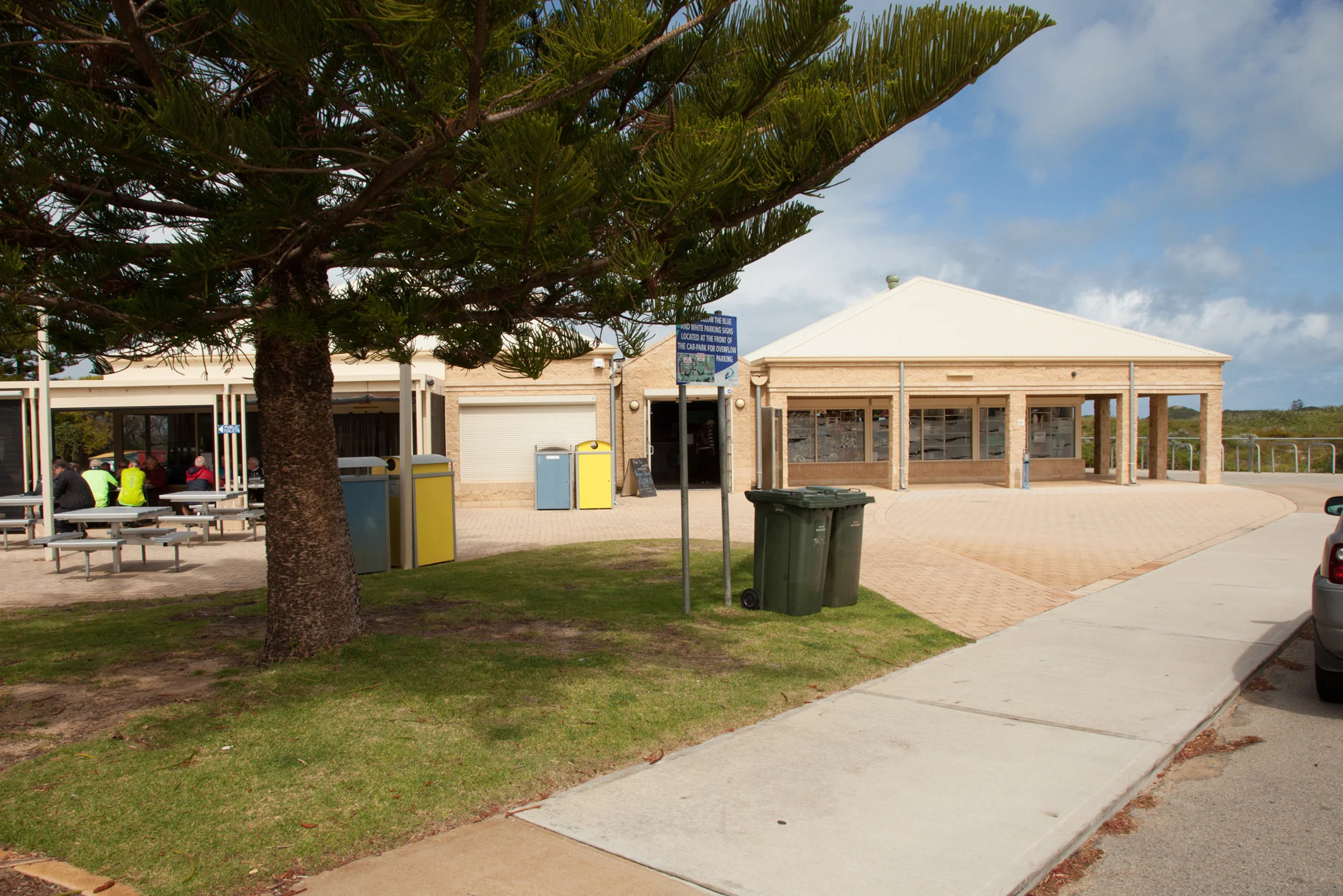
Plate 5: Café and tourist shop at Mersey point
There is also a toilet block as part of this complex.
Continue along the path east of Mersey Point, where the foreshore reserve becomes much narrower (Plate 6), showing signs of erosion. A sea wall is visible near the path, built to protect the road and houses.

Plate 6: Foreshore and path south of Mersey point
Near where Arcadia Drive ends and becomes Safety Bay Road (the roundabout), the foreshore widens and part of the foreshore near the road is highly manicured with well established Norfolk Island Pines (Plate 7).

Plate 7: Foreshore and path near the end of Arcadia Drive ends where it and becomes Safety Bay Road
This part of the coast is a node where there is significant accretion occurring. The coast on either side of this node shows signs of erosion. Figure 3 below is a Google Earth image showing the accretion as a sandy point – called Tern Island – take in 2018. Figure 4 is a Google Erath image taken in January 2026.
Site of significant accretion – formally Tern Island

Figure 3: Location where significant accretion is occurring – Tern Island
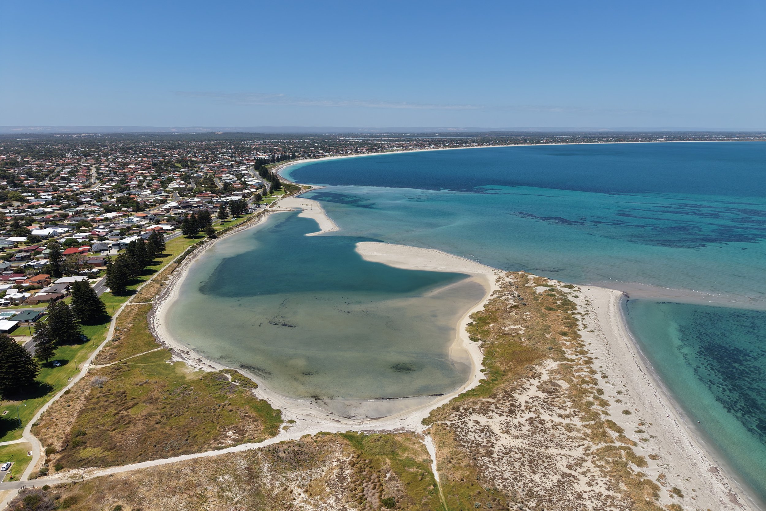
Figure 4: Tern Island in January 2026
As can be seen, what used to be Tern Island is now joined to the coast.
The path goes to the south of the Safety Bay Yacht club: because of the accretion, the club rooms are now well away from the beach, and it’s a long trek for boat owners to launch their boats. Take the sand track going off to the right before you get to the Yacht club. This track leads to Tern Island (Plate 8).

Plate 8: Start of sand track heading towards Tern Island.
There is also a toilet block as part of this complex.
The track leads to the far southern side of the Island, and the beach walk to the point will take you into the Nature Reserve part of the island. The end of Tern Island is the turn around point.
Garry Middle, January 2026