
Burns Beach to Ocean Reef - January 2026 update
Overview
NOTE: this walk is now a bit messy because of the construction works for the upgrade to Ocean Reef Marina.
This page has a full description of this section of the trail, including supporting photographs. You can read this page and/or
Starting point – arriving by car
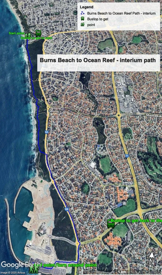
The starting point is the beach front at Burns Beach, opposite the café and at the end of Ocean Parade.
Getting there using public transport and starting point
The best way to get to the start using public transport is to catch the Joondalup line train to Joondalup train stations, and catch bus 470 to the end of its route on Ocean Parade, which is 90m from the start point.
Turn around point
At the time of writing (January 2026) the turn around point is existing boat launching area at the south end of the marina.
Getting back to the start from the turn around point – if you don’t want to do an out-and-back walk
The best way to get back to the start using public transport in this interim period is head back to Ocean Reef Road, cross over and head north (turn left) and head up to Hodges Drive and turn right (east) onto Hodges Drive. Walk on the left side of the road for about 500m to a bus stop. Take the 460 or 462 bus heading north, and when the bus turn onto Shenton Ave, exit the bus at the first bus stop, cross over the road and then catch the 470 bus back to the start (or go all the all the way to Joondalup Station and catch the 470 bus there).
NOTE: at the time of writing the 460 and 462 do not have a weekend services.
Summary of the walk
Figure 1 below shows the route and the bus stops. The total one-way distance is 4.6km making it a 9.2 km out and back walk.
Figure 1.
Water and toilets
Any toilet blocks are noted below in the text initalics. These are also sources of potable water. Any additional drinking water taps and showers are also noted initalics.
Walking Guide
About 150m north of the starting point, ant the northern end of the carpark, is a toilet block and shower. There is also a look out opposite the starting point with sweeping views of the coast (Plate 1).
Plate 1: The viewing platform at the start of the walk

From the start point head south past the café and caravan park along the red bitumen dual use path. This was and will be once the marina is finished, very simple walk – take this path all the way to the Ocean Reef marina. However the current walk is a bit messy at the end as the marina is approached.
The dominant landform here is shallow soils over limestone, as can be seen in Plate 1, which results in the coastal vegetation being primarily less than 1m. This makes this walk one of the best in the region, with many places with sweeping coastal views (Plate 2).
Plate 2: An example of the sweeping views along the path and the low vegetation.

After 1.4km there is a formal look out (Plate 3) with sweeping views (Plate 4) and a park with a toilet blockat the southern end of the carpark and showeron the paths to the beach.
Plate 3: Lookout.

Plate 4: Views from the lookout.

There are two smaller parks after about 220m and 350m past the lager park, the second one has a shower.
About 2.4km into the walk, there is a bitumen beach access path that has steps to the beach. From here the path continues on but it leads to a dead end at the construction site (no access) – 400m. To finish the walk and get access to the existing boat launching facilities to should head inland at this 2.4 mark as getting access to the end is via Ocean Reef Road.
Take this beach access path, cross over to the walking path on the east side of Ocean Reef Road, continue on it passed the roundabouts with Resolute Way and Hodges Drive. After about 200m passed Hodges Drive you’ll see a road heading into the marina – Boat Harbour Quays. Cross Ocean Reef Road and take the path on the south side of Boat Harbour Quays. Turn left at the T junction then right into the large carpark and walk to launching area at the water’s edge. This is the end point/turn around point.
NOTE: the construction is all taking place north of here and so hopefully this end point won’t change
© Garry Middle, January 2026