Overview - Updated January 2026
This page has a full description of this section of the trail, including supporting photographs. You can read this page and/or
Starting point
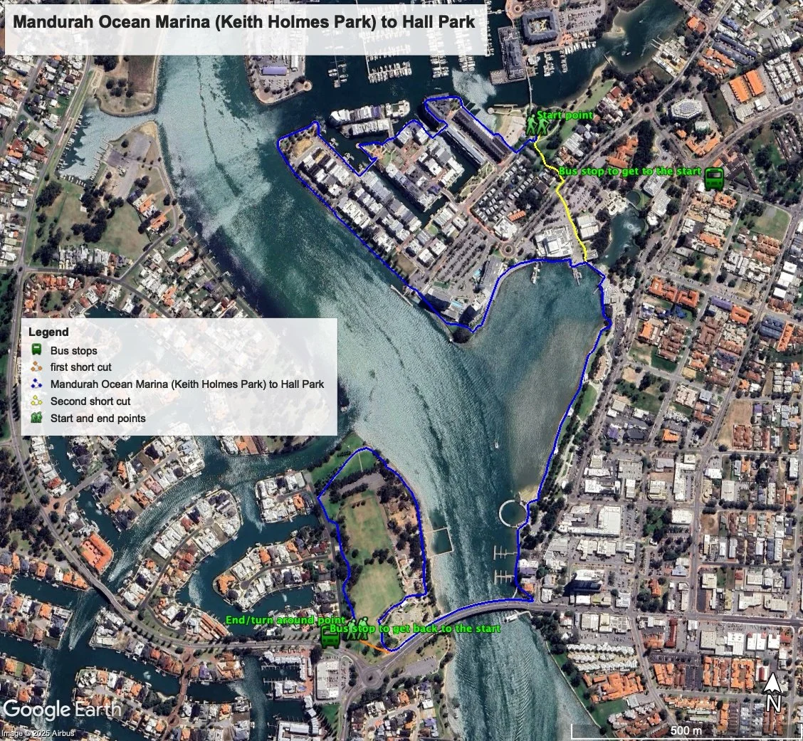
The starting point is the park and small beach part of the Keith Holmes Reserve within Mandurah Ocean Marina. There’s a busy carpark here and street parking on The Lido – see Figure 1.
Getting there using public transport
The best way to get back to the start using public transport is to catch the 584 bus – its a 700m walk. Get off the bus at the stop just before the Peel Street roundabout just after Sholl Street. Walk the 20m up to the roundabout and head down Peel Street to the end. Take the path off to the left through the grassed area to the shaded playground and beach. This is the starting point.
Turn around point
The turn around point is very south west corner of Hall Park across Leighton Place
Getting back to the start from the turn around point – if you don’t want to do an out-and-back walk
The best way to get back to the start using public transport is to head west along Mary Street about 250 and catch the 591 bus to the Mandurah Train stations, then catch the 584 bus. Get off the bus at the stop just before the Peel Street roundabout just after Sholl Street. Walk the 20m up to the roundabout and head down Peel Street to the end. Take the path off to the left through the grassed area to the shaded playground and beach. This is the starting point.
Summary of the walk
Figure 1 below shows the route. The total one-way distance is 4.2 km, making it an 8.4 km out and back walk. NOTE: there two short cut backs to the start: walking straight on to the bridge from the turn around point reduces the walk by 900m (shown in orange), and the one just passed Simmos Icecreams on the way back will reduce the walk by a further 1.5km (shown in yellow), making the out and back distance of 5.9 km.
Water and toilets
Any toilet blocks are noted below in the text in italics. These are also sources of potable water. Any additional drinking water taps and showers are also noted in italics.
Figure 1
Walking guide
As can be seen from Figure 1, the first part of the walk skirts around the main part of the waterfront of the southern half of Mandurah Ocean Marina, mostly along formal paths.
From the park head along the small beach and turn right and head along the board walk on the waterfront (Plate 1), passed some restaurants and cafes, to the round park, and then follow the waterfront boardwalk from here around the apartments until you arrive at a bridge (Plate 2).
Plate 1: Boardwalk near the start
Plate 2: The first bridge
Cross the bridge and immediately turn right to follow the waterfront, turning sharply left after about 60m. Head towards and around the circular park, across the bridge (Plate 3) and follow the foreshore along to the right, then left and left again along a straight section for about 600m (Plate 4).
Plate 3: The next bridge passed the park
Plate 4: The straight section of the waterfront
The waterfront then turns left and then curves passed the Mandurah Performing Arts Centre (Plate 5).
Plate 5: Path passed the Mandurah Performing Arts Centre
Continue on the boardwalk, which becomes a small bridge, but turn right once you get to more San Churro along another boardwalk (Plate 6) and onto the main Mandurah foreshore.
Plate 6: Boardwalk passed San Churro just before the main Mandurah foreshore
Continue along the foreshore path and after about 400m you will see toilet block on your left.
As you approach the traffic bridge that crosses the estuary, you will come to a small shopping area with cafes etc (Plate 7).
Plate 7: Near the end of the main Mandurah Foreshore, with shopping area/cafes and bridge
Take the boardwalk along the waterfront but turn left into a narrow lane way with multiple coloured brick paving – Plate 8 (the path is closed ahead of this).
Plate 8: Small laneway
At the end of the laneway turn right and onto the dual use path part of the bridge (Plate 9) and cross to the other side.
Plate 9: Start of the dual use path part of the main bridge over the estuary
As the bridge dual use path come to an end take a sharp right turn and follow the path along the foreshore (Plate 10) passed a toilet block and a small amusement park – this is Hall Park.
Plate 10: Path on foreshore in Hall Park
At the end of the foreshore and before you get to the entrance to the canal estate, there is a war memorial well worth a visit (Plate 11).
Plate 11: War Memorial
Follow the path through and passed the memorial, head back down Leighton Place, and after about 60m join the formal path about 20m to your left within Hall Park.
NOTE: There is no public access to the waterfront in this canal estate as only resident have access, and there are fences keeping the public out (Plate 12).
Plate 12: Typical waterfront in the canal estate with only residents having access
Where this path begins to veer left back towards the bridge, this is the turn around point.
Garry Middle, January 2026


