Overview - updated January 2026
This page has a full description of this section of the trail, including supporting photographs. You can read this page and/or
Starting point
The starting point is South Mullaloo beach carpark on Northshore Drive, about 1.2km past Mullaloo Surf Life Saving Club.
Getting there using public transport and starting point
The best way to get to the start using public transport is to catch the Joondalup line train to Whitfords train station, and take the 460 bus, which unfortunately only runs on weekdays. The nearest bus stop is the second bus stop after the bus turns on Northshore Drive from Whitfords Ave. It’s a short walk to the carpark.
Turn around point
The turn-around point is the main beach and parkland area in the centre of Hillarys boat harbour.
Getting back to the start from the turn around point – if you don’t want to do an out-and-back walk
Head south towards the main carpark and turn left, cross over Southside Drive and turn left (Head north) on the dual use path parallel to West Coast Drive, and walk about 50m to a bus stop for bus 423. This bus heads north for about 200m to the Hepburn Ave roundabout, then head south back along West Coast Drive and will eventually terminate at Warwick Station. Catch the train north, exit at Whitfords train station, and take the 460 bus back to the start (see above).
Summary of the walk
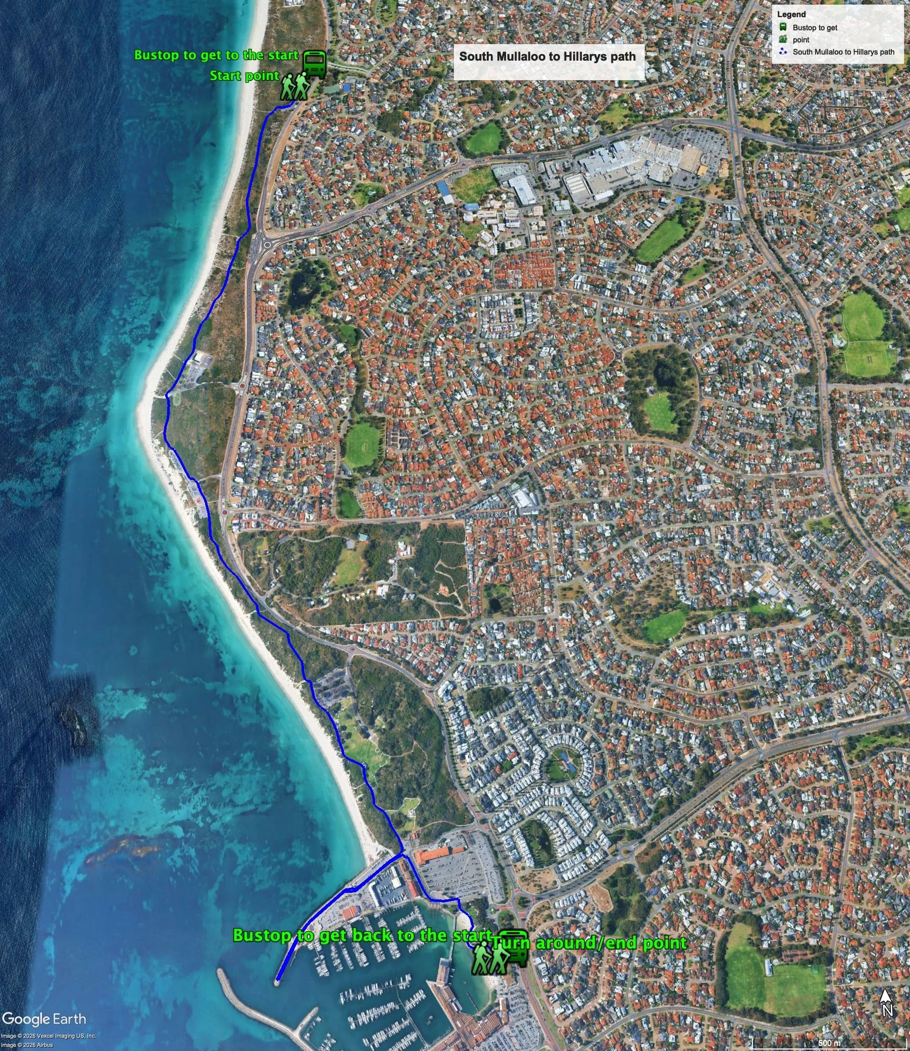
Figure 1 below shows the route. The total one-way distance is 5.2 km, making it a 10.4 km out and back walk. NOTE: This walk can be shortened by 1.0km by not walking to the end of the northern rock wall of the boat harbour. This shorter walk has total one-way distance is 4.1 km, making it an 8.2 km out and back walk
Water and toilets
Any toilet blocks are noted below in the text in italics. These are also sources of potable water. Any additional drinking water taps and showers are also noted initalics.
Figure 1
Walking guide
This walk is described walking south from the starting point.
From South Mullaloo beach carpark (there are no facilities here) head south along the dual use path, which runs through the foreshore reserve, which, for most part, is around 50m from both the beach and Northshore Drive, all the way to Hillarys. The vegetation along the path is a mix of low shrubs and bushes up to 3m, which tend to block views of the ocean (Plate 1).
Plate 1: Showing the typical vegetation along the path
About 750m from the start there is a toilet and shower block. After another 550m there is a large grassed park and carpark with a toilet and shower block and drinking water fountain (Hillarys Neach Club and near Pinnaroo point).
Continue along the path, past a mobile sand dune which is slowly moving across the path (Plate 2).
Plate 2: Mobile sand covering part of the path
After another 450m the path runs along the western edge of a carpark, which also has a toilet and shower block.
After another 800m there is another carpark and large grassed park (Whitfords Node Park) with toilet and shower blocks. The path runs along the western edge of the park. There are two relatively high sand dunes between the park and coastal road, both of which have lookouts at their high points. There are paths to the lookouts on the eastern side of the grassed area.
The path continues passed the park for another 80m to another grassed park with an artificial wetland and the buildings at the northern end of Hillarys boat harbour are visible (Plate 3).
Plate 3: Grassed park with an artificial wetland at the northern end of Hillarys boat harbour
The path runs on the western edge of a small carpark, and after about 70m the path ends at a zebra crossing across Northside Drive, which is the road that runs along the northern rock wall of the boat harbour (Plate 4). This is the point where you can choose to do the shorter or longer walk.
Plate 4: The path ends at a zebra crossing across Northside Drive
For the longer walkturn right here and head west along the concrete and limestone path that runs parallel to the road (Plate 5).(For the shorter walkcontinue south across the road – see below.)
Plate 5: The path that runs parallel to the road.
After about 400m there is a toilet block and the road ends, but the path continues along the narrow section of the rock wall to a lookout/lighthouse, which is the turn-around point for this section of the walk (Plate 6).
Plate 6: The lookout/lighthouse at the end of the rockwall
There are some good views from the viewing platform (Plate 7).
Plate 7: Views from the viewing platform of the lookout/lighthouse
Head back along the path to the zebra crossing across Northside Drive where the coast path ends. This is where the shorter walk begins.Cross the road and head south along the path next to the carpark and the after about 50m turn left and cross the service road and turn right onto the path that runs along the western edge of the boat trailer carpark (Plate 8).
Plate 8: The path that runs along the western edge of the boat trailer carpark.
The path veers left past the boat launching ramp, and turn right at the second zebra crossing passed a statue of dolphins to the small but wide sandy beach that backs onto a grassed area. Walk along the path to a larger beach – this is the end/turn-around point. There are toilet and showers here as well as cafes and other shops in the main part of the boat harbour.
© Garry Middle, January 2026


